La Niña: Understanding the Global Climate's Cold Phase
While we often talk about the weather every day, it's the bigger, repeating patterns of the climate system that shape the seasons, droughts, and heavy rains across the entire planet. Among these patterns, the El Niño-Southern Oscillation (ENSO) stands out as one of the most powerful. ENSO is a mix of ocean and air movements in the tropical Pacific, and it changes between three phases: El Niño (a warm phase), normal conditions, and La Niña (a cooler phase). La Niña, which means "the little girl" in Spanish, might sound harmless, but it's a major force in the atmosphere that can change weather far beyond the Pacific and cause serious problems for people and the economy.
This article looks closely at how La Niña works, going beyond just saying it's "cold water" to uncover the deep ocean and air connections that drive it. We'll explore how scientists spot the start of a La Niña, look at its wide effects around the world, examine the economic impacts, and consider how climate change is affecting this long-standing weather pattern.
1.The Basics: How the Pacific Goes Cold
To understand La Niña, we need to first look at what happens in the tropical Pacific under normal conditions and how the Walker Circulation works.
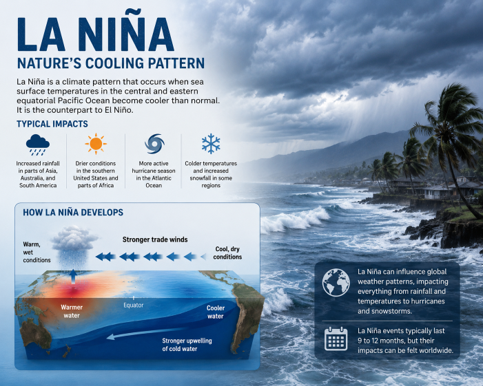
Normal Conditions
Normally, strong winds blow from east to west across the Pacific. These winds push warm water toward Asia and Australia, building up a thick layer of warm water in the western Pacific. This warm water leads to a lot of evaporation, rising air, and strong thunderstorms in the area of Indonesia and the Philippines. At the same time, off the coasts of Peru and Ecuador, the movement of surface water allows colder, nutrient-rich water to rise from the deep ocean. This cold water cools the air above, making it harder for that air to rise, leading to drier conditions in that region.
La Niña Shift
During La Niña, this system becomes more intense. For reasons that are still being studied, the trade winds strengthen greatly. They push even more warm water toward the west, making the sea level in the western Pacific much higher than in the east. This creates a supercharged warm pool in the west, increasing thunderstorm activity and strengthening the Walker Circulation.
At the same time, the stronger winds cause more upwelling in the eastern and central Pacific. A large area of cold water, much colder than usual, stretches from the South American coast westward. The temperature difference between the warm and cold areas increases, which makes the trade winds stronger and keeps the La Niña state going. This natural feedback loop between the ocean and the atmosphere is a key part of the mature phase of La Niña.
2.Spotting "The Little Girl": The Details
Detecting La Niña is more than just looking for cool water; it needs careful monitoring by major weather organizations. The process involves both ocean and air data. The main way scientists classify ENSO phases is by looking at sea surface temperature (SST) changes in key areas of the Pacific, especially the Niño 3.4 region, a large area across the equator.
The National Oceanic and Atmospheric Administration (NOAA) declares a La Niña event when the average temperatures in this area drop at least 0.5°C (0.9°F) below the long-term average for three consecutive three-month periods.
But temperature is not the only sign. The atmosphere must also show a response. This is measured using the Equatorial Southern Oscillation Index (EQSOI), which looks at pressure differences between the western Pacific (like Darwin, Australia) and the central Pacific (like Tahiti). During La Niña, pressure is very high in the central Pacific (because of the sinking cold air) and very low in the western Pacific (because of the rising warm air). When both the ocean cooling and pressure differences meet the criteria, scientists officially declare a La Niña.
3.The Global Effect: Teleconnections
La Niña's influence doesn't stop at the Pacific. The large amounts of cold energy released change the position of the jet stream, the high-level winds that guide weather patterns. These changes create "teleconnections," which are weather effects that spread far beyond the Pacific.
La Niña's effects vary based on the season and how strong the event is, but some effects are common:
North America
- Northern Track: La Niña often moves the Pacific jet stream north. This leads to colder and wetter conditions in the US Pacific Northwest, western Canada, and the Northern Plains. It can bring a lot of winter snow to the Cascades and Rockies.
- Southern Divide: South of the jet stream, the weather tends to be drier and warmer than normal. The US South, from California to the Southeast, often experiences droughts during La Niña winters.
- Severe Weather: In spring, La Niña can change wind patterns in the central US (like Tornado Alley), creating conditions that are more likely to lead to severe thunderstorms and tornadoes.
South America
- Wetter North, Drier South: In general, northern Brazil, Colombia, and parts of Venezuela get more rain and can face flooding. Meanwhile, the Southern Cone (southern Brazil, Uruguay, Argentina) gets drier, which can hurt major farms.
Asia and Australia
- Deluges in the West: The warm pool in the western Pacific, made stronger by La Niña, increases monsoons in Asia and northern Australia. These regions often see deadly flooding and mudslides due to the heavy rain. Australia often has its worst floods during La Niña years.
- Typhoon Frequency: The cooler waters of the central Pacific change typhoon patterns. Fewer intense storms may form in the central Pacific, but more typhoons may develop closer to Asia, including Vietnam and the Philippines.
The Atlantic Hurricane Season
One of the biggest effects of La Niña is how it changes the Atlantic hurricane area. While El Niño causes strong wind shifts (winds that change speed or direction with height) over the Atlantic, which can break up developing tropical storms, La Niña reduces these shifts. Without this breaking force, combined with warmer ocean temperatures, La Niña often leads to a very active and dangerous hurricane season in the Atlantic.
4.Socioeconomic Impacts: The Toll of the Cool Down
The changes in weather caused by La Niña lead to major real-world problems, creating serious economic and social challenges.
Agriculture and Food Security
Agriculture is one of the most affected areas. Droughts brought by La Niña in major grain-producing regions, like the US Southern Plains and Argentina, can cause widespread crop failures, which threaten the global food supply and raise prices. At the same time, heavy rainfall in parts of Asia and Australia can flood fields, destroy crops, and block transport, causing different but equally serious agricultural issues.
Disaster Management
The heavy flooding and increased hurricane or cyclone activity linked to La Niña put a big strain on disaster response systems. In Southeast Asia and Australia, major infrastructure damage and displacement of people are common during strong events. In North America, the threat of a very active hurricane season means higher preparedness levels and can lead to billions of dollars in economic losses.
Energy and Water Resources
La Niña also affects energy markets. Colder winters in the northern US and Canada increase the need for heating fuel. In areas that experience drought, like the US Southwest, La Niña can make water shortages worse, which is important for both homes and power generation from dams.
Fisheries
One rare advantage of La Niña is found in the eastern Pacific. The strong upwelling brings cold, nutrient-rich water to the surface. This boosts phytoplankton, which is the base of the ocean food chain. The increased food supply leads to large numbers of anchovies and other fish, helping the fishing industries of Peru and Ecuador.
5.La Niña in a Warming World: The Climate Change Question
A key question for climate scientists is how global warming is affecting the ENSO cycle. The tropical Pacific has been switching between warm and cool phases for thousands of years, but now the overall climate is warmer.
The science is complicated and still developing. Some models suggest that climate change could lead to a more "El Niño-like" average climate (as the atmosphere warms faster than the deep ocean, possibly weakening the Walker Circulation), while others suggest that La Niña events might become more frequent or stronger. There is growing evidence that both strong El Niño and La Niña events are becoming more extreme. A warmer atmosphere holds more moisture, making the heavy rains of a strong La Niña even worse, and a warmer baseline can worsen the droughts that La Niña causes.
Conclusion: Navigating "The Little Girl"
La Niña is more than just a change in ocean temperature. It is a powerful influence on the global climate system, showing the complex, strong connections between the ocean and the atmosphere. Although it happens in the tropical Pacific, its cold influence changes wind patterns, jet streams, and storm paths around the world, causing some areas to get dry and others to get wet.
Although it is called "The Little Girl," its effects on farming, energy, water safety, and human well-being are far from small. As we face a future with a more extreme climate, the need for better monitoring and long-term forecasts of ENSO becomes even more important. Understanding La Niña is no longer just interesting for weather experts; it is a key tool for helping societies and economies prepare for and adapt to the big changes in the global climate.